|
HISTORICAL MARKERS OF LT. THOMAS
BARLOW CHAPTER
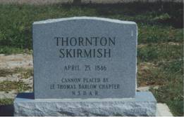
| | In 1914, General James Parker, head of Brownsville Military District, brought from Old Fort Houston four old siege guns to mark sites of major battles of the Mexican War. One was placed on Galveston Ranch off the Military Highway at the site of Thornton Skirmish. (Our first engagement with Mexico.) It occurred on April 25, 1846. Captain Seth B. Thornton and 56 American Dragoons were captured and eight were killed.
President Polk said, "War exists by act of Mexico. American blood has been shed on American soil."
Erected by Lt. Thomas Barlow Chapter, NSDAR, June 1939. |
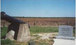
Thornton Skirmish marker
and cannon
|
Thornton Skirmish marker |
|
A cannon was placed within the breast works of the old earthen Fort Brown in 1942 by Mrs. Davenport, historian, replacing the original by marble which was erected by General Zachary Taylor in April 1846, who left Major Jacob Brown in command. Maj. Brown was killed defending the fort May 9, 1846. In 1938 the original was reconstructed with a marble plaque mounted in concrete.
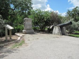
The other two cannons identified the sites of the decisive battles of Palo Alto and Resaca de la Palma May 8th and 9th, 1846, which decided the Rio Grande should be the boundary between Texas and Mexico. These cannons replaced marble slabs which had marked the sites many years previous, because vandals had stolen bronze tablets from historic markers placed by our organization. These are on the Paredes Road between Los Fresnos and Brownsville near the sites of the battles of Palo Alto and Resaca de la Palma. They removed the cannon from the battle sites and placed them on the highway so passersby could see them. The cannons were removed and placed on gun carriage in 1937 by Mrs. B. M. Freudenstein,
history chairman of the Lt. Thomas Barlow Chapter. It sits inside a
roadside park. 
Cannon marking Palo Alto Battlefield
(members Helen Herridge and Grace Johnson)
|
 |
|
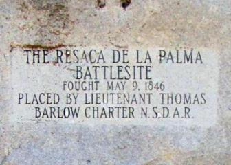 |
| Cannon and marker at Resaca de la Palma Battle site |
On the Boca Chica Highway, about half way to the gulf, is the marker to the so-called “last battle” of the War Between the States” on Palmetto Hill, between confederates at Fort Brown and the Federals on Brazos Island. It occurred May 13, 1865, more than a month after Lee’s surrender.
In Hidalgo County you may find a marker calling attention to Sal del Rey, the old salt lake bed which is on King Ranch property. It supplied salt to Northern Mexico.
|
Home
The content contained herein does not necessarily represent the position of the NSDAR. Hyperlinks to other sites are not the responsibility of the NSDAR, the state organizations, or individual DAR chapters.
For technical problems with this site,
contact the webmaster.
|